Rancho La Brea was formed in 1828 when Antonio Jose Rocha was deeded land from Mexico by the alcalde (mayor of sorts) in Los Angeles. Rocha was the first documented Portuguese settler in Los Angeles who in 1815 deserted The Columbia, a schooner at port in Monterey, filled with fur bound for Asia. He and the nine other sailors who deserted were eventually round up but in some weird deal, the 25- year- old Rocha and the other Catholic sailors were able to stay in California, while the Protestant deserters had to return to the ship. Rocha and another young deserter from the Isaac Todd , John Gilroy (Garlic capital in Santa Clara County), would both become prominent pioneers in California.
Rocha spent some time in jail but his friendship with the comandante of Monterey eventually gave him freedom and provided introductions to other prominent Spanish and Mexican community leaders. Rocha bounced between Monterey, Santa Barbara, San Diego and eventually in 1826 he landed at Mission San Gabriel. In Los Angeles he established a business and married into a well-known Mexican family (Alvarado). Two years later, with a partner who was a Mexican citizen, Rocha was deeded Rancho La Brea. The partner (Nesmisio Dominguez) has no known history with the rancho and probably was only in the deal because of his citizenship. He was later bought out by Rocha’s family. The deeded Rancho La Brea property was 4,444.4 acres or one square league.
The practice for ranchos was the land was usually surveyed by two or three people who would ride on horseback and sketch out the territory indicating any landmarks such as hills or trees or streams. One map of Rancho La Brea from 1840s is in the Bancroft library at Berkeley.
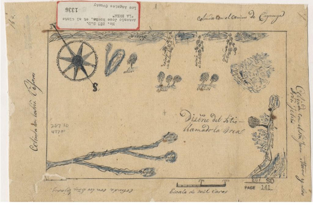
I have not called the library to discuss the map but what I believe we are looking at is the tar pits and their watery ponds (on the south) and upper right is a swamp which I have seen before in other books and maps and I think it might be around Melrose in WeHo (near Pacific Design center where the water table is very high). Aliso means sycamore which are native to Los Angeles and on this map there seem to be clumps of them at the mouth of Laurel Canyon and the other two canyons which might be Nichols and maybe Cahuenga since Rancho La Brea went as far east as Gower. The stream on the eastside is Longwood Creek which runs through the golf course in Hancock Park and eventually feeds into Ballona Creek.
On today’s map, the boundary of the rancho is (roughly) Wilshire on the south, Sunset on the north, San Vincente on the West and Gower on the East. As any of us who live, work, shop and drive in this map, we can tell you, Rancho La Brea is big, crowded and full of traffic.
From all the writings I can find it seems Rocha and his family never lived on the ranch but lived downtown in the pueblo. The ranch was used for cattle both during Rocha’s and subsequent owners’ era. Rocha died in 1837 and his widow Maria Dolores and children would later have to prove they owned Rancho La Brea to the United States Government in the 1850s. In the end, the Rocha family would win the lawsuit but were broke due to legal fees they owed their lawyer, Henry Hancock. They ended up deeding the land to Hancock to pay their debt and why I live in Hancock Park and not Rocha Park. This is how many of the ranchos left the hands of Californios (Spanish & Mexican Californians) into white Americans. Sigh.
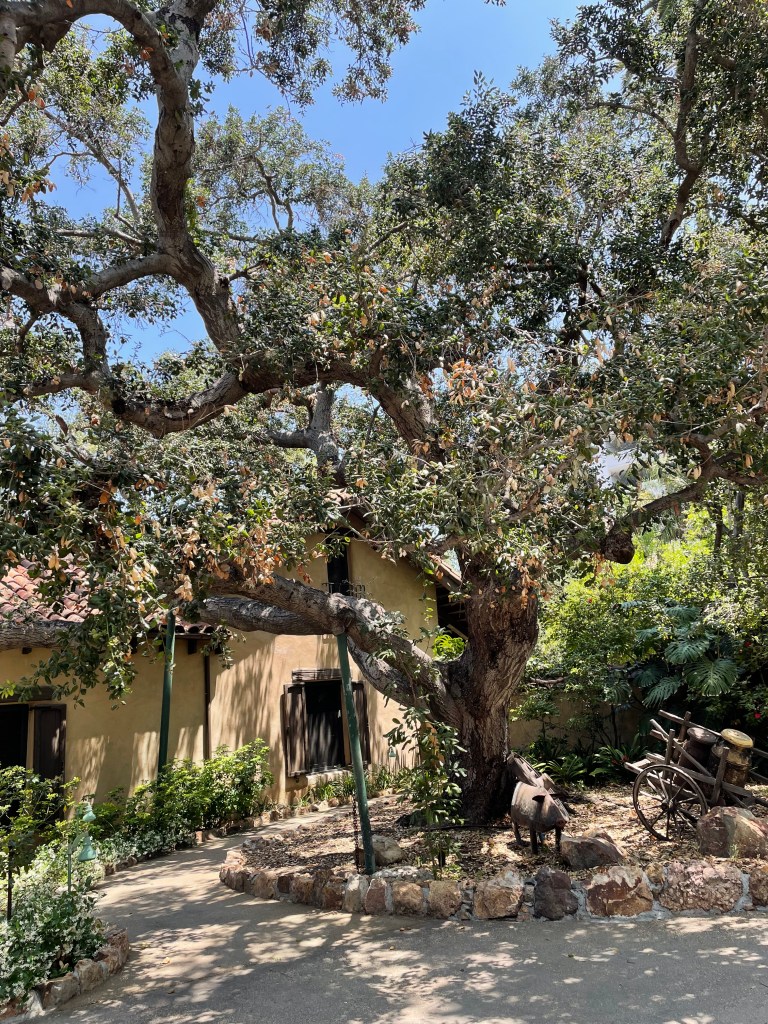
The lawsuit and battles lasted over ten years, and during that time the Rochas would rent out the rancho to earn a little money. One of the renters was sheriff James Thomson. The adobe he lived in (and probably built in 1852), that the Gilmore family later lived in and still own it is like everything good in Los Angeles, it is hiding in plain sight in the middle of Farmer’s market. It is Behind American Girl and next to Woodranch BBQ. I remember as late as the early 2000’s walking between The Grove and Fairfax I would hear the roosters cockadoodling.
One of my favorite secret roads runs east west between the adobe and CBS and somedays with the air is hot and a santa ana wind is blowing and the BBQ smoke wafts from Wood Ranch I swear I almost feel like I am in some other place from long ago when a Portugeuse awol sailor without legal status could build a nice life for himself and his family in the land of Alisos.
Tracy

Wonderful, my husband is a direct descendant of Antonio Jose Rocha he was my husband’s 3 times great grandfather.
I’m trying to find out about the home Antonio lived in with his family in the Pueblo I heard it was a city hall at one point are there any pictures. Thank you
LikeLike
Very cool about your husband’s connection to Antonio. When I poked around in the census for 1860 it seems he was living in the pueblo not far from a Chapman. I think there might be an archivist connected to Olvera street or South West Museum who could help figure out which was Rocha’s house. Love to see a photo if you find one 🙂
LikeLike
My father, 4 sisters and I are also direct decendants to Antonio Rocha. All of them still live in Hancock Park.
LikeLike
Hi there Antonio jose rocha was my father’s grandfather he would My great-grandfather….. They lived off of.
Canon road and the 101 freeway at 1 time…. There’s also the roacher Adobe house that my direct grandfather built-in downtown LA off of sentinel…. The natural history museum in LA used to have a lot of information on the family. I don’t know if they do still they’re used to be a painted mural Avantonio Jose Rocha and his wife….If you would like to contact me it would be my email address jaywesttc@yahoo.com
LikeLike
Portuguese are Iberian, European and Caucasian. Mexican people are a mix of Indian and Iberian and perceived as non white. When the Rocha family deeded the LaBrea ranch to Hancock to pay off legal fees it was a Caucasian to Caucasian transaction. The original Rocha was white, he was Iberian Caucasian.This persistence that non whites lost to whites is clearly an error in this article.
Rocha and Hancock were both Caucasians. The footman had to make Portuguese Hispanic is intellectually lazy and morally disingenuous.
LikeLike
Thank you for your comment. I appreciate the Iberian nuance and understand the European presence in Caliornia both North and Baja California. As for Rocha, he died in 1837. It was his heirs who had to pursue the court case with the federal government. Rocha’s widow Maria Josef Alvarado was born in 1802 Mission San Gabriel. Her mother was born in 1770 Loreto Baja and her grandmother Maria De La Luz Ruz was born in 1744 Loreto. As you indicate, European men who married in New Spain (Mexico) usually had wives who were indigenous or descended from indigenous. It would be unlikely that Rocha’s wife had a mother or grandmother who was European. Rocha’s children therefore would be part indigenous. So, it would not have been Caucasian to Caucasion transaction. I don’t believe I used the word Hispanic or Latino in my post. But to your point and I am grateful for it because it is a good reminder, the two words are often used interchaneable but they are not the same word. They refer to the origin and not race. Thank you again for your comment.
LikeLike
The infraction was the Englishman,Hancock toward the Portuguese, Rocha. This is Caucasian toward Caucasian. Mr. Rocha’s family were not directly involved with the property loss. Yes, they were Hispanic since Rocha married a Mexican woman, a beautiful combination for the both of them. It was a business deal betwern Rocha and Hancock and infortunate at that. My family is in central California, Rocha from Terçeira, Açores. The Rocha surname is quite spread.
LikeLike
Hi AvaA, thanks for the reply. Don Antonio who came to Los Angeles from Portugal arrived in Monterey California in 1814. He worked and lived in and around several missions in CA and eventually in 1826 he married Maria Josefa Dolores of the Xavier Alvarado Family of Los Angeles. In 1828 he with a partner applied to the Los Angeles ayuntamiento for Rancho La Brea and was granted the rancho. Don Antonio Rocha died in 1837. The rancho was now in the hands of Rocha’s heirs. Henry Hancock arrived in California in 1849, twelve years after Don Antonio died. So, the man from Portugal and the man from New Hampshire never met. Don Antonio’s children and wife (as discussed would be part indigenous) hired Mr. Hancock in 1852 and spent many years in court. Eventually they owed Hancock money and the heirs deeded the land to him in 1860. There is a very good article about Don Antonio Rocha in JSTOR. “El Portuguese: Don Antonio Rocha Californias’ First Portuguese Sailor.” Vol, 66, No. 3 (Sep.,1987), pp. 185-195 (8 pages). There are a lot of Rocha’s in California for sure. While we are not Rocha’s. My mother’s family also came from the Iberian Peninsula to New Spain in the 1600s. I think all these stories add to the rich history of California.
LikeLike
Hi, I’m currently searching for more information about this Rocha family because of a family genealogy research that I’m doing (I’m not a professional). It all started when one of my sisters saw an old oil painting displayed in LACMA (?) of a man dressed like royalty that had a very striking resemblance to one of my grandfathers (whose surname is Rocha and had portuguese ancestry). I cannot find this painting anywhere and the little research I’ve done keeps leading me to this don Antonio. Any information of where I could find paintings or drawings of this man or his children would be very much appreciated!
LikeLike